

Maps
As part of crafting their narratives concerning past events, historians utilize images—portraiture and photographs. Most importantly, they work up maps: political, military, demographic, and economic maps that capture the kinds of changes history studies. In support of telling America’s story, one film at a time, our team is building out a bank of maps arranged in chronological order, beginning with the Great Migration of Euro-Asians to North America and extending into recent events in American history.
Chronology of Events in Maps:
Pre-1492 Migratory routes of first humans into North America, plus archaeological evidence of early human settlements in North America.
1375 Catalan Atlas, made by Abraham Cresques.
1489 Map of the known world that Columbus would have used; interactive map of four Columbus voyages to New World.
1501 Amerigo Vespucci (“America”) voyages to Brazil, first to realize continental America.
1507 Waldseemüller map, first to use the name America.
1513 Juan Ponce de León voyage to Florida.
1519 Álvarez de Pineda map of Texas coastline.
1521 Ferdinand Magellan voyage around South America into the Pacific, circumnavigates the globe.
1524 Giovanni de Verrazzano exploration of American east coast.
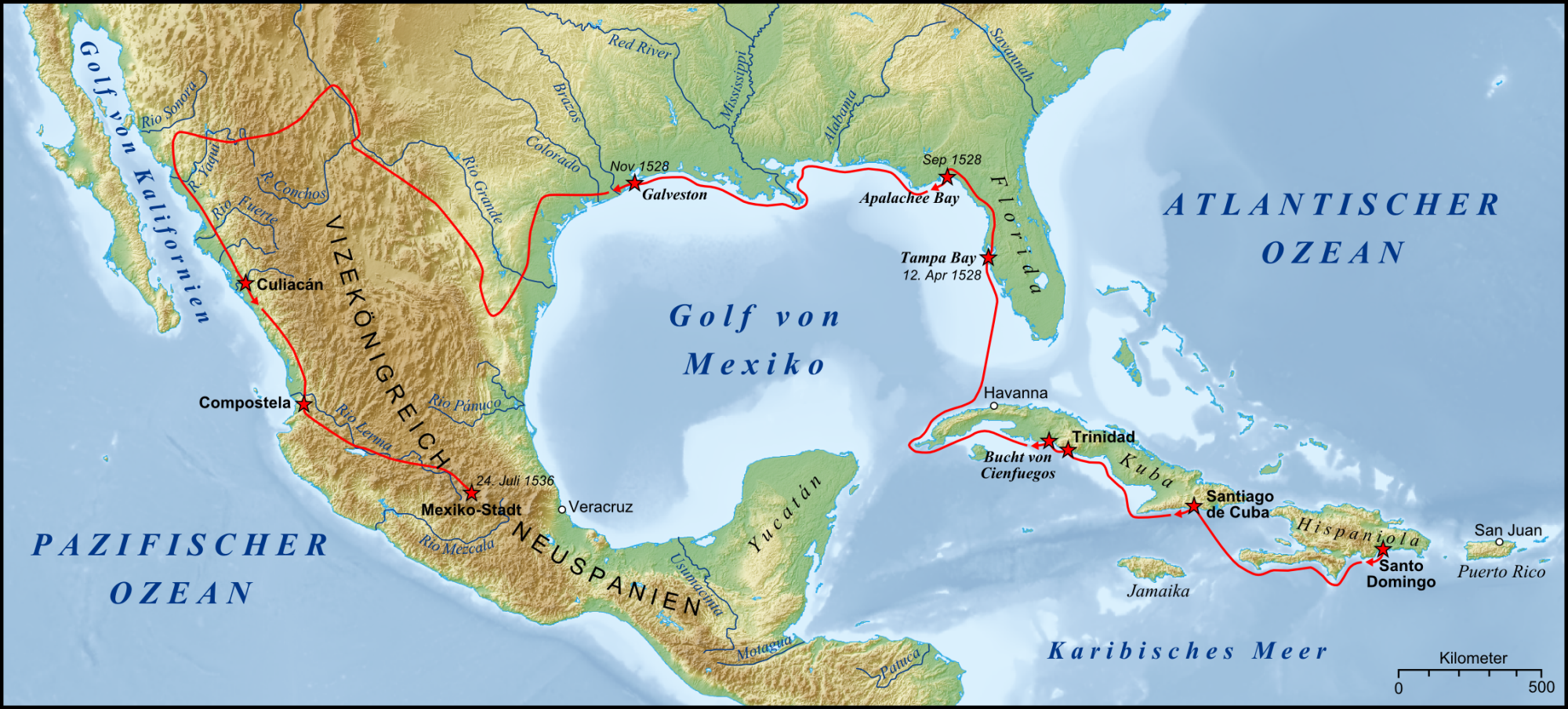
1534–1536 Álvar Núñez Cabeza de Vaca, exploration from Florida to the Gulf of California.
1539–1542 Hernando de Soto (1500–1542) explores Florida, Georgia, and Alabama, crosses the Mississippi River.
1540–1542 Francisco Vásquez de Coronado explores territories from Arizona to Kansas.
1542 Juan Rodriguez Cabrillo navigates the California Coast.
1584 Walter Raleigh lands on Roanoke Island; calls the land, Virginia.
1607 Jamestown settled.
.png)
1620-1691 Plymouth Colony developed.
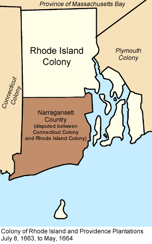
1663 Rhode Island established.
1670 Map likely used to determine boundaries of colonial Maryland.
1681 Pennsylvania established; disputes over land claims last for a century.
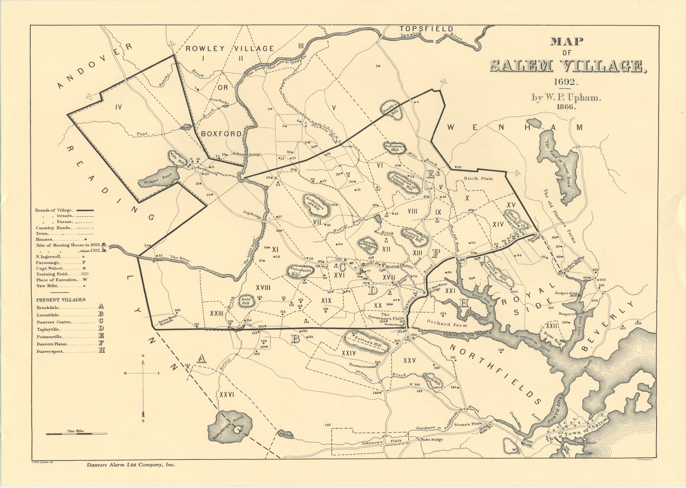
1692 Witch trials conducted in Salem.
1750 European colonies in North America on the eve of the French and Indian War.
1754-1760 Major battles fought in French and Indian War.
1763 Treaty of Paris determined European holdings in American colonies.
1763 Map of King George III’s Royal Proclamation Line.
1770 Paul Revere’s map/plan of the Boston Massacre.
1773 Map of Boston around the time of the Boston Tea Party; map of the route taken from meeting house to the wharf.
1774 Map of the Thirteen Original American Colonies.
1775 Map of Boston and Vicinity: Lexington and Concord, Initial Dispositions and Movements, 19 April.
Maps will be added to this bank chronologically as we progress through history with the films.